
Autumn / Mysto swell

One question Craig. Do the weather/swell models take into consideration the "squeezing" effect of Cooks Strait?
Even with Cooks Strait squeezing these winds, I still reckon we'd be much better off without NZ there. Even this swell would have been bigger without NZ, given the fetch was yet again dissected by the sheep shaggin isle.
Hi Don,
They don't need to take this into account, ie the models don't have to do any calculations regarding topographic features. The wave model is just simply fed in the GFS wind field which does have this effect included in the weather model.
The thing to point out here though is that without Cook Strait squeezing the pressure gradients this fetch would of been nowhere near as strong and the swell would of been much smaller.
As you can see just north of the 30-45kt winds (along New Zealand's Shipwreck Coast) the winds are much weaker and this is because the pressure gradients aren't being affected by the topography.
As has been discussed before; New Zealand acts as a sort of anchor for eastwards tracker storms and weather systems and if it were removed we would see these systems continuing racing to the east with no swell whatsoever spreading back into the East Coast.
So even though it may appear New Zealand blocks a lot of swells (and it does), it is probably responsible for generating a larger number of swells that wouldn't of been produced in the first case if it didn't exist.
Fair enough then. Cheers to the sheep shaggers then!!!
Thanks Craig.
Your welcome Don.
I always wondered the exact effect NZ had on weather systems and had an inkling that it actually attracted weather features and caused them to do strange things due to the high mountain ranges cause slight presure differences and micro climates, SST differences between east and west coasts etc etc These can only really be a good thing for helping build systems that impact on Australia's east coast with swell IMO.
I saw this sat pass the other day but figured the fetch wouldnt be wide enough to have a impact over a large area of the Australian east coast? I was more looking at the sustained E/SE at the top of the north island and that fact it was progged to move west back toward the Tasman. Is QLD likely to see any swell off either of these?
That sustained fetch is a bit touch and go poncholarpez but the mix of this and the infrequent SE groundswell should peak later tomorrow at around 2-3ft+ across the exposed beaches south of the border with a touch smaller waves in SE Qld. Swell should hold into Sunday as well but this will be more a product of the slowly westward moving but weakening fetch.
Swell should hold into Sunday as well but this will be more a product of the slowly westward moving but weakening fetch.
By: "craig"
Steve's indicating the swell from Sunday is from the Cook Strait stretch (if I'm reading his extended forecast correctly)? and he's called it smaller than your 3ft+ Craig?
Personally, I think Sunday should come in in the very inconsistent 3-4ft class IMO at open exposed beaches, and from the Cook Strait fetch.
How did it go up your way Don? I was up the coast a little from Sydney and the swell pulsed to 3-5ft into the afternoon and then eased from 3-4ft on Sunday.
Looks like Sydney saw the forecast increase to 3-5ft as well.
Gotta say it's been a great start to autumn and with some tropical activity due early next week it looks to continue!
We'll just have to ride out a period of small waves this week..
Sat pushed into the 3-4ft(maybe the odd bigger one) range (from the Cook strait fetch), normally those fetches favour Sydney more than NENSW/SEQLD.....this one seemed to piggyback on the already existing sea state.
Sun, eased back a notch into the 3ft range.
I didn't surf on the weekend....only Friday. But I got some pretty reliable reports of some decent surf on Saturday (4ft+), more so at swell magnets down Steve's way, with still inconsistent 3-4ft sets pushing through on Sunday.
I was up shooting around the north Coolum area on both Saturday and Sunday mornings. Saturday was very consistant and in the 2-4ft range and nice and peaky. Sunday was a complete different swell, was 2ft+ with the odd bigger set, although the period increased the swell was gutless in comparrison to Saturday and the early low/mid banks hated it.
here's another one just like the other one. www.metservice.com/tv/index#severe
So the solid E/SE groundswell has arrived in Sydney this morning and you can see it clearly on the Sydney wave buoy with peak periods jumping to a pretty impressive (for this region) 14 seconds.
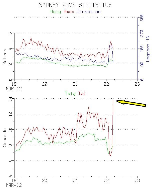
You can also see the direction (blue line in top graph) has gone straight East (90deg) overriding the local Southerly(180deg) windswell early this morning that was generated by strong southerly winds overnight.
Open beaches are now picking up 4ft+ sets but gusty southerly winds are limiting surfing options. Tomorrow should be a different case with all day offshores and an easing swell from 3-5ft!
Tomorrow should be a different case with all day offshores and an easing swell from 3-5ft!
By: "craig"
If only I could say the same about SE Qld!!! :(
Swell looks to have arrived earlier than modelled in SE Qld this morning, so I'm thinking it should peak just after lunch today, with tomorrow being smaller than modelled.
I wouldn't worry too much Don, there's a couple of pulses in the mix regarding this swell and it should still be a good size tomorrow morning, with a peak likely overnight tonight.

^ yip and moving in a westerly direction towards the end of todays arvo run.
I had a dream about this system last night.
By: "freeride76"
And? Do tell more then Steve.
Was it a nightmare Steve where you were stuck in cold Victoria when the swell peaked?? Could become quite the reality, although there'll be no lack of swell down at Bells.
Yes, it was something like that Craig.
And then my brother called me and said the Ox was clean 10-12ft.
Not looking near as good anymore :( then again models are all over the place at the moment.
Now if we can just have what EC was predicting the other night ill be happy.
That's why that chart should of been placed in the Mythical Chart Thread.
Low looks as if it will form behind the North Island now, producing a less consistent but still fun sized long-range E'ly groundswell later next week.
Autumn has started with a bang across WA, and southern NSW.
I missed the weekends waves around Sydney but got to enjoy this mornings offerings with torrential rain and clean 4-5ft walls running through at Manly.
I thought I'd bring up a chart showing one of the East Coast's funkier swell sources that to the untrained eye would be missed by the casual weather observer.
While todays large SE groundswell was generated by a low positioned just offshore from Sydney, over near New Zealand a fetch of 30-45kt E/SE winds were created exiting Cook Strait (the gap between New Zealand's North and South Island).
Below is a satellite pass over the fetch this morning and you can see the strong winds being generated out of Cook Strait.
This strait squeezes and amplifies winds blowing from the east and hence we get this phenomena where significantly stronger winds are produced on the western side of the strait.
There is usually a 2 day lag between when the fetch is produced and when the swell hits Sydney, so this is the new E/SE groundswell I have forecast to arrive on Saturday in Sydney.
Wind speeds on the satellite pass are a little stronger than forecast yesterday and so I would know expect a strong but inconsistent 3-5ft swell to develop during the day Saturday across Sydney, the Hunter and South Coast.
Back before surf forecasting was done regularly this swell probably would of been labelled as a 'Mysto Swell' due to it arriving 2 days after the main swell event and not being visible on any Australian synoptic chart.
These days though nearly every swell can be hindcast and tracked back to reveal its source if you put in enough time and effort.