
ECL 10/06/2012

Don't want to jinx it so aint gonna comment on this one. Madly planning mind you!!!
Feck Ben!!!! Don't anyone else talk anymore about this upcoming swell please. I'm planning and don't need it jinxed!!! So shut the feck up everyone!!!

I put in the direct image links instead Don. I think the code didn't like part of the URL which it interpreted as something weird (annoying, I know.. will fix soon).
And yes - what a spectacle it's been on the surfcams this afternoon!
The wind stayed offshore all day up here, best day in ages! Tomorrow looks even better!
Brisbane wave buoy hit 10.5m tonight. Shes getting a workout lately, lol.
Hopefully after the next few days, the few good banks on the coast are not ruined :( .. weekend is looking for the open beaches.
How are the pics from Kirra yesterday arvo :O sweep looks insane this morning.
Yeah looks so insane, did you get to go out goldy?
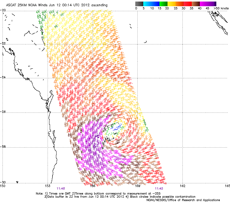
Here's a nice satellite pass of the East Coast Low responsible for the swell..
Nope, didn't have time today wouldn't bother with the sweep either. Went out yesterday mid-day, really wish i wasn't busy during the late arvo looks like missed out on a magic session, oh well plenty more to come.
BTW, i see you are now doing the QLD forecast Craig, Steve give it up?
Craig, the bom has this low tracking away to the NE slowly. Will the better alignment with the coast the further north it goes, produce similar size waves but better quaility swell in the upcoming days?
Poncho, it won't be similar size to late yesterday/today, but it should be a well aligned groundswell over the upcoming days around the 5-6ft class, slightly bigger freak sets at the known swell magnets. I just hope the near shore system hasn't destroyed the banks on the beachies and reverted back to the the usual storm bar crap!!!! :(
Current central pressure in the ECL is of the order of 986hPa. My question is, what defines a cyclone? The old school of central pressure would mean this would be a Cat 1 cyclone yeah? Even nowadays with circular winds, you'd have to think at the core this system would be close to a Cat 1....maybe it's lacking some strength in it's NE quadrant?
Looking at the latest satellite animation, it looks as though it may have had an eye too in it's early stages?
needs to be warm cored to be a cyclone. If this had happened in summer it probably would have turned in to one further up in the coral sea. This one was formed off a combo of the cold pool moving over SEQ/northern NSW and a lower trough higher up in the Coral Sea merging.
Yeah, i was looking at it yesterday and was thinking this would be a high cat 1 cyclone maybe low cat 2 if it were warm cored?
Hi Don,
The whole formation and development of a Tropical Cyclone is different to East Coast or Mid Latitude Lows, and one easy identifier is that Tropical Cyclones are warm core systems while these winter storms are cold cores.
TC's are powered by the release of latent heat while these cold core systems are driven less by latent heat release and more the upper level jet and trough.
If the current jet stream were over a Tropical Cyclone, firstly it wouldn't form due to the strong upper atmospheric winds and if it was present it would be torn apart quickly by these strong upper winds.
Just saw your comment Poncho, basically the same answer :)
For the forecasters-Any chance the east coast low will keep moving east instead of south east once it gets near nz? I'm worried the nice westerlies on the weekend will have nothing to fan down this way.
thursday onwards will be epic....still no answer to why youre doing the forecast and not shearer ??????
We're restructuring our forecasting setup in preparation for some new products, Victor. Other than that, we're not able to discuss internal matters.
Don?? where are you? Thoughts?