
Sneak peak of new Swellnet forecasting tools

Also.. our calculated 'surf heights' are 'surfers feet'. That is.. head high is 3ft, 6ft is double overhead and so on. However users will be able to switch to 'face feet', and also metres.

In the next week or two. Can't come soon enough! Just doing some final testing this week.

20ft in WA on Sat/Sun and it's dribbling all week on the east coast, what a contrast.
Yeah we could have shown the Gold Coast forecast but it's a boring straight line of nothingness.

looks good, do you have any new locations or is it the same as the current site?
sandspit, yes we have over 2,000 international locations, all of which have been carefully calibrated. We're iniitally launching with around half of the list but we'll roll the rest out over the weeks once the site is live.
BI9999, yes we are keeping 16 day forecasts for all locations. The accuracy for some locations (especially tropical destinations ie Indo, Tahiti) is fantastic.

So with the swell direction i guess it just goes like a compass in degrees, yeah
With direct south and north are 0 and go up to 90 when hit direct East and direct West which makes NE, SE, SW, NW all 45
Swell direction in a forecast is good, got to have swell direction, size is often nothing without ideal direction.

Ben, will the apps be launched at the same time, and will there be an android app?
Goody, I love it. More reason for original thought and not following the ewes.
ID, spot on. Actually, we use 16 points of the compass so you'll see a general direction label (ie WSW) but it'll be followed by the specific swell direction in degrees (ie 59).
salt, yes the Apps will be launched around the same time - both iPhone and Android. Actual release dates may vary slightly due to differing store Ts and Cs however they are being built concurrently as a near-identical pair of Apps.
Ben, can you also switch between metres and feet for the open ocean swells (Primary-Tertiary)? Working in metres for swell just does my head in!!! :)

Im slightly confused ben correct me if I'm wrong but on a compass isn't nth 0 degrees, e 90 degrees, sth 180 degrees, w 270 degrees , so wsw should be 247.5 degrees or thereabouts not 60 degrees , am I missing something?
Don, yeah we'll have those options available shortly. Funnily enough Craig prefers metres whilst I prefer feet!
TRN, yeah there are a few small glitches in the direction settings at the moment, they'll be fixed shortly.
Oddly enough, the difference between meteorological convention and oceanographic convention is the complete opposite. According to the respective conventions, 'north' wind arrows point down, while 'north' swell/current arrows point up! However, for Swellnet we've kept them the same ('north' points down), but it's requiring a little fudging in our backend to do so - and there's still a few little bugs in the system to be cleaned up.
haha... fudging in your backend...
sorry ben, new forecasting looks amazing.

So much colour and in columns, if you could get the columns to roll to a stop as they come on the screen so it looks like a poker machine you'll have me hooked.
Shaun, we've got a simple bar chart version too. I'll get Craig to upload a screen grab of that shortly so we can show you.
No ben ,I love the colours, it would be just so mesmerizing if you could make the colours move. I'm a simple person if it has colour movement and some sort of loud noise to go with it I'm happy.
Here's a screenshot of our current Torquay forecast. The numbers are virtually identical to Craig's manual forecast issued yesty - except our new system will update four times every day, seven days a week.
Look great! Are you guys still going to put out manual forecasts for the current regions? I assume you won't be doing all 2000 new locations!
That's a great question carpetman. We will still be issuing written forecasts (similar to what's on the current website), however we've decided we won't try and manually adjust the forecast bar graphs etc.
The reason for this is that the computer model forecasts update 4 times daily, so we'd have to match that in order to keep it streamlined. We've also significantly increased the number of Australian forecast locations, so the amount of work required to 'tweak' the bar graphs (and other forecast products) would be time and cost prohibitive.
For what it's worth, we've been monitoring the automated output for the last eighteen months and it's very accurate. Sure, it's not completely perfect but then again neither are our manual forecasts. However we are confident that our system is by far and away the most accurate surf forecasting system in the world.
Anyway once the new system is up and running we've got a few add-ons for the forecast section that will be gradually rolled out over the following months. This will bridge the gap between the computer-generated and manual forecasts.
More incremental windflows, swell angles and especially secondary and tertiary swell factors. Winner!
Ben, it would be very nice to understand how your models are different to others that are currently out there. I'm assuming you still use GFS/WW3 but if yours is different an explanation as to how/why would be very useful thanks.
Don, I can discuss some of the methodology behind our forecast system, but other parts of it are commercially confidential. However, it'd be easier to explain things once the new site is live - that way I'll be able to point to specific, real time examples (so you can validate our claims for yourself). So if it's OK, I'll resume the discussion on this particular point then.
One more little teaser - and this functionality is exclusive to Swellnet.
Regions known for multiple swell directions (ie the East Coast of Australia) have been categorised due to the way different beaches react to different swell directions.
In our manual forecasts we usually attribute these forecast size anomalies to 'south facing beaches' (or similar), but until now we've never been able to accurately graph it as such.
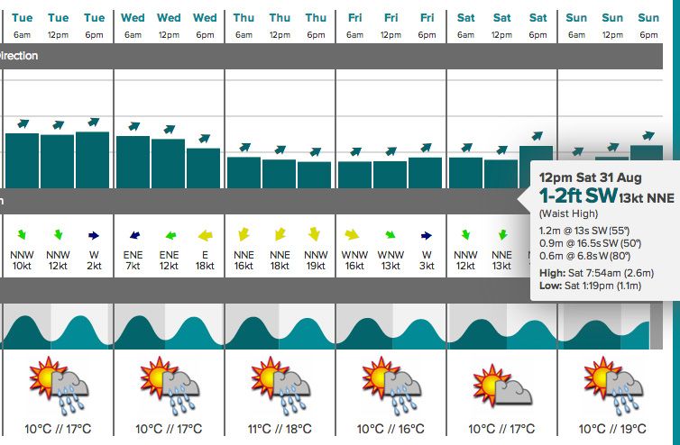
The graph below is for Sydney later next week onwards (ie 13 days ahead). It shows a small residual east swell Thurs/Fri/Sat, ahead of a building southerly swell late Sunday, peaking early Monday before fading throughout the day.
Our forecasting system now knows how to differentiate between open beaches and south facing beaches, the latter of which is represented by the orange bar on top.
So, at 6am Monday the forecast is for 2ft at regular Sydney beaches (for example Maroubra, Narrabeen, Mona Vale), reaching 2-3ft at south facing beaches (Bondi, Curl Curl).
thats pretty nifty, will be keen to see how it predicts big swells on the east coast
Thanks guys, really appreciate the positive comments. Can't wait to get it live!
Hi Ben, will you be offering an API or ability to load a widget on a website?
topgeer, Swellnet data has always been available to third parties via a subscription service (coordinated by Weatherzone) and this will remain unchanged. However we will expand on this functionality over the coming months to include website widgets and the like.

Would it be at all possible for you to not cover the area between Scotts & Newy as no-one surfs there anyway & it will save you some money.
I can understand why you would give out long term indo type forecasts but what about the locations in oz which are currently not on there? can you guarantee that these locations will remain 'off the radar' or are you planning on adding them to your portfolio?..It looks the goods if you are doing an OS trip or similar but it could be really annoying for locals!!
There's no changes to that part of our Surf Report network, LR, however we do have new forecast points for a couple of places between Newcastle and Coffs Harbour. Honestly though, there's not a great deal of difference between their output and that of nearby regions. Just tweaks the numbers a little more.
barley, we are expanding our location database in Australia. However, the forecasts are not beach (or reef) specific - each forecast point covers a broad area. Those forecast locations with tricky coastlines - such as yours - will still require intimate local knowledge to score the best waves.
Looks great!! Only critical feedback from a design pov is that the colour scale blue-red could match the "weight" of the colour box with the "weight" of the swells better. Under reduced visibility (designers have apps to simulate this, but you can also squint) the 0.x swells are as strong or stronger than the 7, 8, and 9m swells due to the high contrast and everything else recedes into the background a bit. You could change the colour weights so that the blue swells go further into the background and the mid-range comes out a bit more (the 3.x colour esp. hard to scan on my screen) and the visual picture of the swells would be more legible.
Minor issue, good luck getting it out the door, will look fwd to making it my new forecast home!
Ben, love the "south facing beaches" tab addition. Very impressive. Will be interesting to see how well it's calibrated for locations like the Gold and Sunshine Coast in south swells as a few degrees difference can make a massive difference to surf heights.
Thanks Don. We've been monitoring and testing it for the last eighteen months, and our 'south facing' calculation is very accurate here in Sydney, as well as most places on the East Coast. However some synoptic setups will sometimes overcall the SE Qld/NNSW coasts (it's spot on with the 'open beaches' prediction, but s-facing beaches are sometimes overcooked). That being said under these scenarios they're often blown out anyway.
TOS is a Sth facer & will b super hard to accurately predict even with all yo tech. I seen Sth swell days when I should have hit surfers instead(sometimes better shape also) due to equal swell sizes, admittedly it don't happen often. D'bah on the other hand will suit these charts. But props on yo new system. A little advice is to link FB with this shit or u just not progressin, damn u the number 2 surf site in Oz, step up yo. Also video feature access on yo home page would draw we sheep in to hit the shit, I love the still features but u need to adhere to the standard that CW are doin then go above their shiate.
Actually I reckon our model may perform a little better at TOS than D'Bah under south swells. However no forecasting tool is able to (or will ever be able to) accurately predict swell 'shape' or even 'quality' - there are just too many variables at play.
As for your other comments, re: Facebook - we're already well ahead on the pack on that one (compare our numbers), and as for videos, we'll announce something on that in the coming weeks too. We've purposely maintained a low video profile on our website for the last couple of years for a very specific reason and we'll be opening up in that space shortly after the new site goes live.
One last thing, Swellnet is actually the #1 surfing website in the country (as per Nielsen stats, the industry benchmark metric), and has been for the last seven consecutive month.
I'm preaching to the converted here but Swellnet craps on CW, the forums and comments is what keeps us coming back everyday. Sure I check out CW every now and again but once I've had a squizz, there is no need to go back for a while. SN on the other hand is constantly changing and evolving with the differing opinions and imputs of its members and I don't want to miss an Uplift post because I like being confused. The only thing for me is the timing of the daily reports where I live. If it's early I will check the surfsouthoz report first just because he is up before dawn and gets it out early (which is also used by CW), but thats no big deal.
We're upgrading our surf report delivery system with the new website, salt (BTW, where are you - Victor or the Mid?). Won't say much more than that right now however there are significant (and long overdue) improvements happening in that space.
Thanks for replying to all our comments Ben, it shows SN really care for the surfing community. Good work.
Does anyone check Coastalwatch anymore? It seems their website has just slipped further and further, even with the recent upgrade. I agree with Salt regarding differing opinions and the forums. My first interaction here was a huge barmey. Can't even remember what it was about but I was still allowed to comment. I thought I would've gotten banned straight away! It's good that you guys allow free speech about all kind of matters because I don't always agree with what you say.
No Australia data but it would be great to see this incorporated somehow.
Might clean out the lineups a bit haha
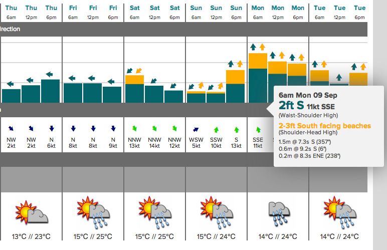
Here's another good example of our model in action, for a developing swell event later this week and into the weekend (for St Helens, on Tasmania's East Coast).
In similarity to our 'south facing beaches' forecast discussed on previous pages, this shows how our model picks up bigger waves at Northeast facing beaches (orange bars) compared to regular beaches (green bars).
With the imminent launch of our website upgrade, I thought I'd give everyone a sneak peek of one of our new forecasting tools: 16-day surf forecasts broken down into specific swell trains, but with our proprietary calculated 'surf height' algorithm at the top. You can also - as per the second image - expand the view into a 6-hourly forecast for each day (we'll also have 3-hourly and 1-hourly data available down the track).
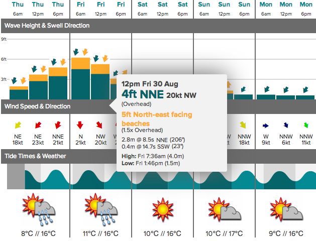
Because the East Coast is under the grips of a small spell of waves, we figured this week's upcoming episode of large surf in Margaret River was a good opportunity to show how the model copes with large variations in ocean conditions.
Expanded view (Fri/Sat/Sun):