
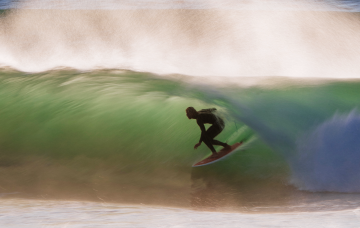
The Donkey Unleashed - video

More footage from the last big swell at Namibia. No it's not as good as Benji Brand's minute long barrel, which frankly has corrupted all of us in terms of expectations. Still, there are some wild barrels to be had from the Billabong SA crew. Skip the obligatory talking at the start, the surfing starts at 1:30. And the name? Donkey Bay is the correct name for the wave now known universally as Skeleton Bay.


Comments
Is there any footage which shows them paddling out and around? If 2ft DI can be a challenge, how the hell do they do this? Loooks relentless.
Paddling back to the takeoff you mean? I think most of the crew walk back. Till recently they drove, someone would be lumbered with ferrying the crew back to the top of the point, park and repeat. But the locals got the shits with that and decided to start enforcing the rules:
https://www.zigzag.co.za/featured/if-you-wanna-ride-dont-drive-locals-implement-no-drive-rule-at-skeleton-bay/
Oh wow. Yes but more so getting out the back, and then dealing with the sweep I imagine is there...?
Tyre tracks at 3.39
Guess not everyone is following the rules. But with a 2 kilometre plus walk you can kinda understand.
Wow, that has to be some of the worst editing I've seen in a surf video, and that is really saying something.
Same - distracted by the editing which killed it for me
This wave is a freak of nature, it's hypnotising
Seriously though, anyone know of any mundane arsed footage of the line up?
Is that a big arsed rip at 20sec?
Saw an aerial shot of it the other day with flash rips - I guess you'd call them that? - about every 200-300 metres down the line. Sorta like a straight east coast beachie but tilted at an angle. The water pushes in but still has to find a way back out, and it seemed to do that at the rips where sand was dredged up and turned the water yellow.
So I suppose guys are using rips to get out then. Not sure how long and small the lulls would be though, as the spot is closer to the source than say a Mex beachie
3.53 tells the story ..... this ain't the " wildeness " anymore ......
Wow, gotta be quick to see that one, but it's packed ay!
yeah, saw a photo where it looked packed.....still, it'd be hard to stay in position and hug the sandbank to paddle into one.
It still staggers me. Of all the thousands upon thousands of sand bottom points around the world there's only one of them that does this. Why is it? What's unique to the bathymetry of Skeleton Bay that allows it to break in that manner?
Same with Chopes. There are innumerable reef passes around the world but only one Teahupoo. What makes it special? As Professor Julius Sumner Miller would say, why the fuck is it so?
'Southey' Sumner Miller....?
hey Stu who are the locals??
Wave looks incredible...I wonder if it ever gets clean offshore?
I reckon Mundaca on its day was/is prety close as it used to hold up to 12'Hawaiin and barrel...for about 300mtrs.....but also flawlessly clean offshores.....
The Walvis Bay locals, I guess. It's just 5 kays away and houses 85,000 people being Namibia's biggest port. Before the wave turned on windsurfing and speed sailing were the biggest sports, so I guess it's a very windy area. The SEer is the predominant winter time wind, not sure how often they'd get a straight easterly.
There may be locals but it's not like Skeleton Bay has always existed. The strong winds are reclaiming the sea at the rate of a few metres per year. The shipwreck of the Eduard Bohlen, sunk in 1909, now lies surrounded by sand about a kilometre from the sea.
See this article that Craig and I wrote about the creation of Skeleton Bay. Excerpt from that article:
"It appears there's a conspicuous absence of locals at Skeleton Bay, especially long time locals, which seems unusual for a wave of such quality near a medium sized township. Yet if we look at historical maps of the region it becomes clear why that is. Just fifteen years prior to Brian's online discovery, the perfect shape of the sandspit that features in so many magazines and videos was considerably different to its current state."
3m/y * 100years = 300m.
Closest distance from wreck to shoreline = 360m at about 280deg.
Distance from wreck to shoreline, in direction of sand ridge which has grown in the lee of wreck (i.e. where the wind has been blowing loose sand; about 358deg.) = 2.74km
In the average direction of the shoreline of those geographical features (seems to be 338deg) = 740m.
I don't think there is a surplus of sand in the medium term and scale, because if there was, there would be no bays/depressions inside of these points... Another thing I noticed is the dark lines sweeping around to the NE, and roughly paralell to the current NW facing shoreline. They're probably semi consolidated remnant shoreline ridges. If direction of growth is perpendicular to the mean or median of these ridges, say 320deg, then the shoreline is 470m from the Eduard Bohlen...
Any other ideas on how growth could be measured?
You and numbers, Mitch. Screw giving the Julius Sumner Miller tag to Southey I reckon you take the title.
Professor Mitch Very Good!
Hahaha, I didn't even mention the Penguin Islands and the possibility of underwater features yet
There's got to be others. If you googlemap it the coastline is littered with similar setups. Worthy of some serious investigations I think
Oh, no doubt, there are others. GE shows a coastline littered with headlands and bays that fall away to the north east. With predominant south swells it's a left point republic. Whether they're as good as Skeleton Bay is another question, and whether they can be accessed is another consideration. It's a big, dry, sandy coast with bugger all towns.
Another wave exposed ,another crew pissed off all for 5 minutes of fame for the exposers. Nothing like crapping in your own back yard
Not quite the same politics in this instance; the wave didn't exist a few years ago and there's a good chance it may not exist (at least at present quality) in the future.
Point taken though. The time from first exposure to global saturation is shrinking.
Skeleton Bay 1973. The wave currently breaks where the wave symbol is:
Skeleton Bay 1992:
Skeleton Bay 2000: