July Set To End With A Bang

Savvy swell watchers would be hard pressed to miss the sandwich of activity that's forecast either side of our country into the end of the month.
A lingering La Niña signal will supercharge a summer-like tropical low in the Coral Sea later this week, while at the same time a strong, slow-moving node of the Long Wave Trough in the Indian Ocean will steer a series of significant polar fronts towards Western Australia and Indonesia.
The setup for the East Coast is more typical of late summer or autumn, with a strong high pressure system moving into the Tasman Sea cradling a deepening tropical low off the south-east Queensland coast. All the parts will move into place this Thursday and Friday. This development aligns with the weak, yet lingering La Niña signal which is due to strengthen over the coming months.
The high is actually set to strengthen and broaden while pushing just east of New Zealand at the same time as the low drops into the Tasman Sea. Such a setup will "spray" the East Coast with easterly swell, as Steve eloquently described it in his Forecaster Notes yesterday, starting large and oversized in Queensland and Northern NSW late this week before spreading down into southern NSW over the weekend and into next week.

Initially due to the low's close proximity and strong to gale-force southeast winds, surfing options will be limited to only the most protected bays and points, but we should see more options opening up through mid-to-late next week as the low weakens and moves slowly east. Thw winds will relax and go more offshore, providing a prolonged, large quality swell event that will last around a week.

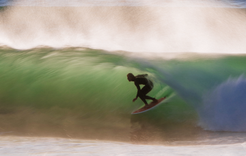
Over to the west, the Long Wave Trough will focus consecutive polar frontal systems up towards Western Australia from later this week, all through the weekend and into early next week.

This will see back to back, large to extra-large W/SW groundswells impacting the Western Australian coast from Sunday through Wednesday next week, spreading up into Indonesia mid-to-late next week.
Winds in general look to be dicey and onshore across the Margaret River region, but for the metro locations and further north, conditions will be cleaner with morning offshore winds.
South Australia will see moderate to large levels of W/SW groundswell spreading east into its west facing coasts as winds improve later in the week, while it'll be smaller and more westerly in direction for Victoria as winds remain a bit of a lottery.
Keep an eye on the regional Forecaster Notes for updates on the most surfable days with the incoming country wide swells.


Comments
Looks like the BOM severely underestimated the strength of the precursor cold pool incursion.
Partly cloudy with showers and a top of 18 was the forecast for here today.
We got cold rain (40mm) and a top of 13 which was reached at 6am.
edit: climbed to 15 at 3pm.
Was a significant cold pool, too. -34C (at 500hPa) over the Tasman after it left your shores.
What's the call for Noosa points size wise?
Crowd wise? Off the charts.
Should be a few cylinders about.
Been a good run of swell in the North West with light winds. I have run out of moisturizer and testosterone boosters.
Gonad Man is cumming your way with supplies
Craig is this only relevant for Indo for next week? Not the following?
Going there late next week, is it too early to call swell for first week of august?
u so on for Indo..beats 1 degree vicco
Ha you’re not wrong
Looks to be another large, follow up swell the week after.
Shades of green all the way down the FC chart.
She's a goer.
Now all you have to do is check the charts three times a day and decide which boards you're taking.
Sweet!
Don't forget the old maxim: Good waves, good boards.
Enjoy!
And in freak of bathymetry will equally cancel each other in the vicinity of Torquay
So maybe nxt week it may all come together with offshores & sustained east swell! Just like all of these east coast lows they can be unpredictable, so time will tell, as always!
as I move into the fourth week of having k-wires in my broken thumb and staying dry, I urge y'all to surf as much as you can, appreciate your water time.
Fark offff!!!!! Shitest 3 years in living memory down ere, had the odd great day but just FARK OFFF!!!! Hey Craig does the opposite happen during la'nino years for southern states , like out of control???
Bloody hell. I've just recovered from a costo vertabral strain and now this!!! I'm getting too old for all these barrels.
Yes once again if the surfcoast gets anything it will be fuck all compared to other parts of the country
This broken record sux
in the last 50 years have we had an end of and start to the year which so many unpredictable and unprecedented weather events ????