
Spring!!!

Yeah, we've spoilt the last few months. This spring season's gonna hurt even harder I reckon.
This is always the best time of year to head OS I reckon.
Still good in Indo/South Pac and shite here.
Come home with a solid deposit in the stoke bank.
Guess you lads are from the East coast cause down here in SA it's been pumping with at least 1 or 2 good days every week. Loving Spring!
Yeah, quite often it's either one or the other. SA/Vic pump and it's terrible on the East Coast, or the East Coast is off the hook and the waves are non-existant in the southern states. Make the most of it while it lasts!
No worries freeride76 - SA is pretty small and all the surf spots are real close together. Your first point of call has to be the Mid Coast followed by the South Coast. Don't bother looking any further - nothing to find.
Oh and freeride76 - you should have been here yesterday, last week and the week before...it was pumping
Yeah I heard the Hump was cranking with sparkling shoulder high lefts reeling down the line all the way to under the jetty! Magic..
Geez a bloke can't even say he's been getting a few nice waves at home these days without the crowd police and the ex-pat cynic having a go. Alright it's been crap here just like the East coast.....happy now?
Yeah, that was tongue and cheek as well Maddog.
I'm back over in a few weeks and cannot wait to head out into the dry, harsh landscape that is the SA surfing experience.
And our run of swell has dried up, so the last few weeks over there have looked amazing from our point of view!
anything on the horizon for the goldy in the next couple of weeks?
Radbone, I can't see Sweet FA mate....unless you're chasing weak NE'ly windswell slop.
And I'd be expecting water temps to drop a few degrees come this time next week too!!! :(
Feck, this is getting depressing!!!!
Although I note something on the long range EC charts out on the horizon may bring some joy to an otherwise woeful looking long range forecast.
Hmmmm, things are looking a little more promising on the charts now!! :)
Are you talking about a low possibly forming off the north east coast DonW?
Doesn't look like it will be either strong or long lasting on the charts I'm checking, but it does look better than nothing.
What do you think at this stage.
Steve?
Not much.
Weak little surface trough thingy.....moves away quick.
To far south for us.
Bit of tiny background tradewind swell if we're lucky...
Well not according to EC Steve. Yeah granted it aint gonna be 6ft pumping, but compared to what's been on offer the last week and what's forecast to be on offer behind this weak low pressure system cradled by a Tasman high combo, it's the best looking forecast yet. I'll take 2-3ft peaky SE swell any day of the week at the moment!!!
Looks a little better on the latest runs.
Depends where it forms. But, yeah, best of a bad bunch, although yesterday saw some pretty fun waves at S facing beaches here.
that ecl is looking pretty dynamic now. Models keep intensifying it more and keep it in the Tasman longer. Should be some nice 3fter's by Tuesday.
oh yeah, GO THE WARRIORS!!
I'd be thinking the swell will be larger than 3ft come Tuesday. Granted it's S/SE in direction which isn't ideal for SE Qld, but it is east of south so that certainly helps.
I wouldn't be surprised if we see 4ft/4ft+ at south swell magnets comes Tuesday, probably more so come Tuesday afternoon.
Biggest X factor now is trying to find a good bank on the massive early morning high tides.
Oh yeah, go the Mighty Manly Sea Eagles!!!
Hey Steve, just checked your forecasts and I noticed that you've updated the surf forecasts for SE Qld and NE NSW, but the Extended Report is still from Friday's forecast?
Did I catch you mid uploading of the forecasts, or have you just updated the surf forecasts (with no update on the Extended Report) this morning to reflect the current evolution of the Tasman Low?
The sand banks should be pretty full from the recent lack of swell. Swell should be quite peaky too which should help things.
Moving beyond this swell, as Don likes to do ;) It looks like we may see another broader Tasman Low forming during the weekend as a surface trough sliding up the southern NSW coast on Saturday feeds off a pool of cold air in the upper atmosphere.
Will keep a close eye on how this one pans out for those heading away for the long weekend.
Thanks Craig. I was actually going to point out this morning the potential for a second Tasman low this weekend, but figured I'd get pounded on again for looking past the first Tasman low!!! ;)
Back to back swells in Spring.
Fella could get used to that.
Sure was a paddle battle this morning though.
Yes I heard the currents down your way were rather wicked this morning.
Craig, your extended report refers to a southerly groundswell to hit tomorrow morning (Thursday am) but I'll be damned if I can see it, unless it is coming from that low that is so far south of us it is off my charts, literally.
Is that the source of tomorrow's expected south ground swell?
As for the charts generally, I'm inclined to be a little concerned. I was expecting wind outside, but it's quiet as a mouse out there right now.
Just wondering if things have moved around a lot with each run? Also, according to the charts the wind will have a lot of west in it from daybreak tomorrow, but your forecast suggests a midday change of direction to w/nw from n/nw.
Up the central coast this week and next and I have to say the banks up here look pretty stuffed at the moment. Some of the fattest waves I have ever seen.
Hi batfink.
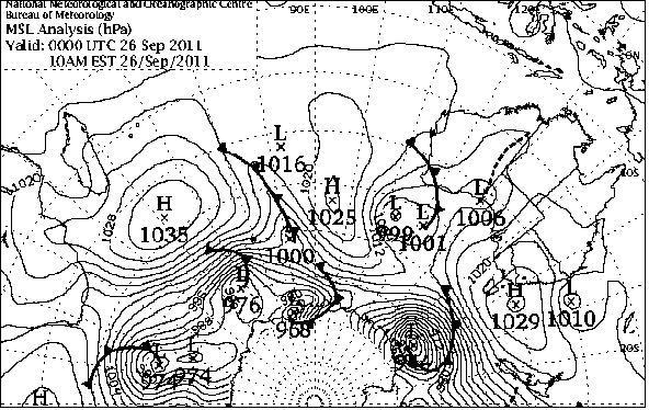
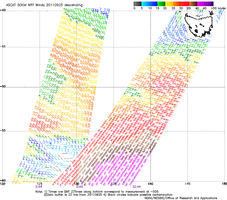
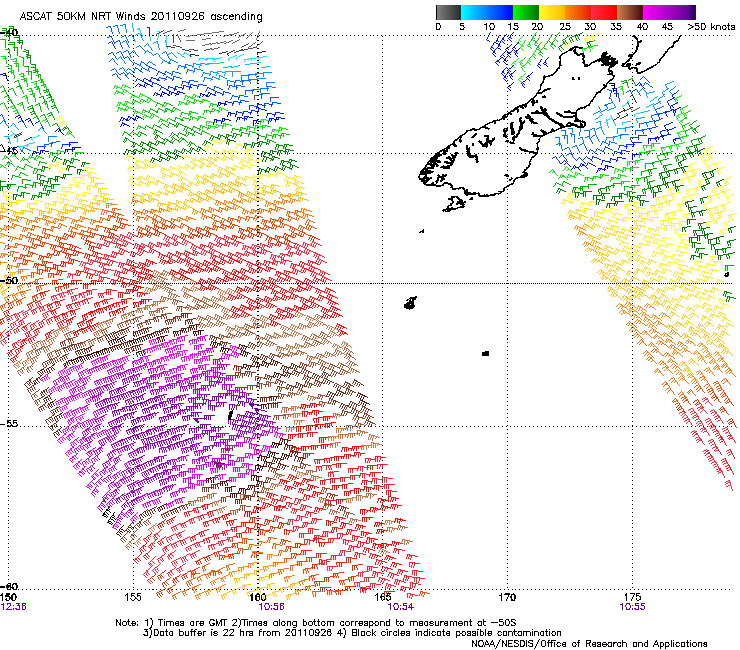
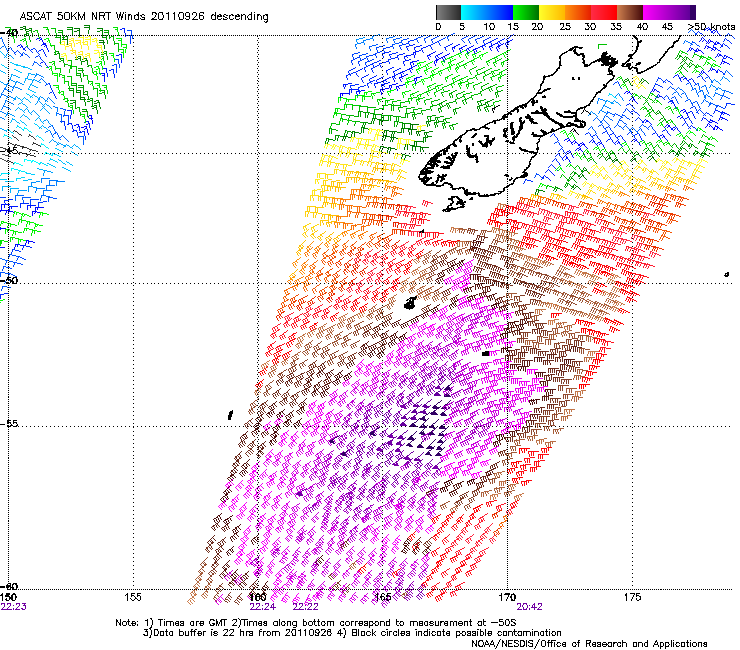
The southerly swell was generated by a deep and powerful polar low to the south of Tasmania, close to the Antarctic Shelf over the last couple of days.
Here's the MSLP map of the low (Australia to the right), and also the ASCAT satellite wind observations during the main swell production of the low.
If you have a look at out SNSW charts, you can see the strong 18 second period pushing north and filling in overnight tonight..
https://www.swellnet.com.au/weather/snsw/charts
Even the keenest of weather watchers would of missed this swell if they hadn't had their eyes on the Southern Ocean charts.
Now this swell is coming up from the south, and it was expected to peak in the South Arm Tasmania this morning. I had forecast 3-4ft, and reports came in at 3-5ft, so it did a little better than expected.
The South Arm is a good proxy for south swells across Sydney coming from polar latitudes, and if you look at the Eden and Bateman's Bay observations you can see the leading edge of the swell has already arrived..
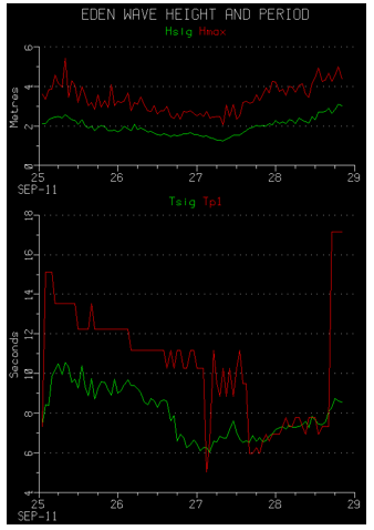
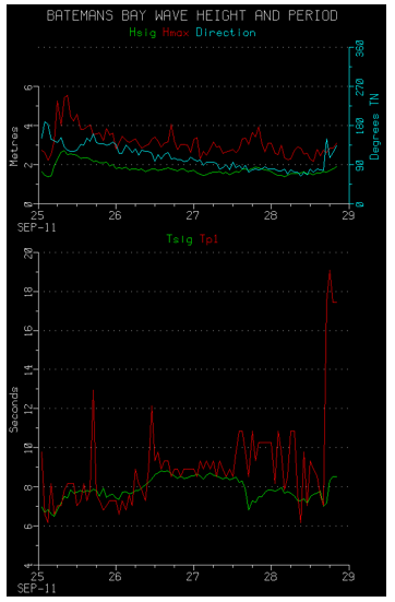
The leading edge of this swell should reach Sydney during the middle of the night, with the peak occurring around dawn. So at this stage everything is on track for an inconsistent 3-4ft south swell as south facing beaches.
Now I have also noticed the lack of strong winds across the Sydney region, but the largest of the NE swell is expected to be generated tomorrow morning, just before the front moves offshore, with a fetch of NE gales being produced east of our coast and all the way up to Seal Rocks.
I have forecast 3-4ft waves at north-east facing beaches, and Manly is the main beach I'm talking about, but Maroubra should also see this size during the morning, with smaller 3ft peaks across other east facing locations.
Now regarding local winds tomorrow, all the charts I'm looking at show a moderate and possibly fresh N'ly tomorrow morning, that may even go N/NE around 7-8am before swinging N/NW around 10am then W/NW at about 12-1pm.
So I'm confident in tomorrow's forecast, and if you can work around these figures you should be able to score ;)
And the leading edge has just been picked up by the Sydney buoy..
www.mhl.nsw.gov.au/htbin/wave_data_plot.com?Location=Sydney
the mornings have been horrible up here... Fat and wobbly, the high tide screwed everything. Hopefully next weeks low is a little gruntier!
Impressive detailed synopsis Craig....keep up the good work.
Poncho, this last Tasman low certainly delivered some grunt, it's more the fact the banks are fecked in SE Qld at the moment, combined with some of the largest high tides of the year.
For me, the next Tasman low (based on current charts) is likely to have more of S'ly direction as oppposed to this week's low which certainly had a reasonable component of SE to E'ly swell direction in it. S'ly swell component's don't favour the majority of SE Qld locations. Local winds don't look great for this next swell either. Still I'm not complaining as it's Spring and there's waves!!! :)
Cheers Don, I'm a little disappointed that Batfink hasn't got back to me after all the effort I put in, haha ;)
He's standing at the beach waiting for that wind to change!!!
Now regarding local winds tomorrow, all the charts I'm looking at show a moderate and possibly fresh N'ly tomorrow morning, that may even go N/NE around 7-8am before swinging N/NW around 10am then W/NW at about 12-1pm.
By: "craig"
Got the W/NW wind change to the minute Craig.....impressive work mate!!!
Just checked out your pics Craig. Feck me, I now know where all the sand from SE Qld has gone....fecking NSW!!!! We'd kill for beachie banks like that right about now. Our bank situation is rather dire at the moment.
BTW, the swell doesn't look as peaky as I would have expected with a NE swell and S'ly swell combo. Also considering the difference in swell periods between the two swells, I'm amazed at how perfectly groomed the waves are. I would have expected a bit of two swells causing more gurgle, if you know what I mean. Was there more one distinct swell in those shots (ie S'ly groundswell)?
NE swell was way more prominent, and looks like winds off the coast were in the 35-45kt range so it wasn't windswelly at all, strong lines of straight NE swell, on an east facing beach :)
Looked awesome Craig.
I hunted up down and sideways on the promise of a late wind shift ...alas it never came and the combination of SE/ESE swell from a retreating Tasman low and NE windswell never came together.
Sounds very similar to a few guys I know yesterday Steve. They waited and waited (and asked me when the NW winds were going to arrive) only to be greeted with devil winds until after dark. Word is that even on the low tide, our outer storm bar situation is dire as the width of the bank is incredibly narrow so the waves fatten up incredibly quickly again on that inner massive gutter.
Can you blokes please send some sand back up this way!!! :(
Thankfully today was a very different story.
Amazed again, that in school hols it was so easy to find uncrowded quality surf.
In fact totally unattended.
@freeride. I heard through the vine there were some really nice waves this morning at certain spots. Nicely groomed sandbars etc...wtf?
Cheers Craig.
I'm up the central coast at the moment, and rarely bother with Maroubra these days.
Surfed south facing beach on Thursday for about 2 hours. Had checked it earlier as well.
East nor east swell was definitely there but it was wonky and peaky, nothing like the photos you put up. Any lines weren't very long, more peaky, and not from an interaction with a south swell.
No south swell at all, not one wave, this was mid morning, and as mentioned on a south facing beach.
I didn't have to wait for the change in the wind, it was offshore with the nor/nor wester.
Pleased to say that as I'm on holidays I'm not checking the internet that much, except for the swell forecast and wind direction.
Banks up here are rooted for the nor east direction. No beach here handled it well IMHO.
On the other hand this morning (Saturday) south swell found some good banks before high tide. Had a very enjoyable surf. Looking forward to more to come. One beach away from the main beach and was sharing it with a couple of blokes. The popular beach was like Bondi on a bad day.
Based on the latest wind obs, it looks as though the low pressure system is forming slightly further to the north than previously forecast?
I had been checking out the beach this morning and clearly a 3'+ swell coming in to the south facing beach.
Get back home and put the board in the car, driving down there hear the radio report a 1-2 ft swell.
Check out the beach I am hitting and it's 3'+.
You can't complain too much about surf forecasting sites making it all too easy when the radio reports aren't even able to get it right.
Feck I hate this time of year for swell. Need to organise a surfari OS in Spring just to break the insanity.
I can't see anything on the long range charts worthy of getting interested in either!!! :'(