
Spring!!!

nice dip forecast for a few runs around fiji with that intense high sliding underneath.
By: "poncholarpez"
Yes, ACCESSG and EC showing something good for this time of year, albeit a mile out in their model run time. GFS not even the slightest bit interested at this stage though :(
pitty about the local winds at the time that trade swell should arrive.
ACCESS G are still persisting with that squashed high out new NZ:) Hope it comes to fruition!
Would love it to come to fruition, but it's fair to say that ACCESSG is the major outlier at present. GFS and EC not really interested.
Agree, sick of these northerlys/ flat crap spring conditions.
Would be nice if that low predicted to form up around Fiji would travel our way rather then slip to the SE with the high...
And like Don said someone blow up New Zealand
And as expected, water temps have taken a nose dive in SE Qld.....colder than what they were during winter (19 deg Gold Coast buoy).
OK, I'm now starting to get seriously fecking angry!!!
And depressed!!! :(
What, you're not getting excited over the first tropical disturbance of the season, TD01F ;)
At least there's some kind of activity out there..
Yeah it's very good to see this early in the season Craig, but with the strongest winds on it's eastern flank and such a compact little system with no cradled high pressure system, I can't say it's getting me excited on the surf front.
Nothing unusual about seeing a small depression in the SPCZ in Nov.
What would be unusual is getting a swell from it.

TD01F?
I'm intrigued by your ideas and wish to subscribe to your newsletter.
Doesn't sound like La Nina to me!!
https://www.weatherzone.com.au/news/brisbane-deserves-a-drink-after-near…
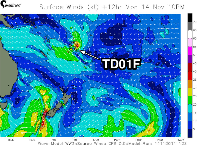
Nick, TD01F stands for Tropical Depression (TD) number 01 of the season.
I'm not sure if the F stands for Fiji, but in any case the first significant tropical disturbance has formed in the trade-belt close to Fiji.
If the atmospheric setup and sea surface temperatures are favourable these TD's can form into Tropical Cyclones, but this one isn't expected to do so.
When the next TD forms it will be named TD02 and so on with each new depression.
Below is an image of the winds feeding into TD01F (upper left quarter of the image) right next to Fiji.
And Don,
I wouldn't worry about QLD seeing its driest start to November in 92 years.
All the signals are there for a La Nina and it has been classified already.
Negative Nino 3.4 Index..

Positive Southern Oscillation Index..

BOM classification of a weak La Nina..
https://www.bom.gov.au/climate/enso/
And by NOAA
https://www.cpc.ncep.noaa.gov/products/analysis_monitoring/enso_advisory/
It's probably worth noting SST's aren't anomalously warm off the QLD coast yet but are off the WA Coast.
If you look deeper into the water column though you can see that ocean temperatures are anomalously warm below the surface in the Western South Pacific linked to La Nina and this will probably mix up through convection over the coming month or two..
Equatorial Ocean Temperatures from sea surface to 450m's

I certainly can't remember a November that's been this flat for this long AND this fecking dry and hot.
This shit aint funny anymore Huey!!!
seems like the whole east coast oz has been flat for November. Next year i'm goin West. Looks to be pumping waves at the moment.
Nothing too weird about this pattern. Nov/Dec '08 was dry before a developing La Nina deluged us come Xmas time.
SEQLD has been a bit unlucky to miss out on some of these trough-induced t-storms.
We got 2 inches the other night from one.
Certainly though, we've been in a kind of "nino feeling" state wrt to local atmospheric conditions.
I think the development of TD01F and the next major high cell coming through at a lower Latitude may go some way to flicking the switch to a more classic Nina state.
Also this extended pattern of weak high pressure and light tradewinds in the CS will see SST's rise quickly in the current regime.
I've got no doubt the switch will be flicked big-time.
But we still have plenty of time, it's quite normal to be tortured by this kind of pattern through Nov/Dec.
Thanks for posting up those graphics Craig.
Not sure I'd call one of the driest November's on record "nothing too weird". And looking at the swell archives, Nov 2008 (particularly the first 2-3 weeks) had some cracking surf, with fairly consistent swell for most of the month.
Nov 2011 has not had one surfable day thus far (apart from the first weekend in Nov).
Can ya ask Huey to fecking flick that switch NOW please Steve!!!
Craig,
thanks!
I'll start counting from now and nod knowingly when this acronym surfaces in future discussions.
btw - I'm in SA at the moment and there is a neat little 2-3ft swell pushing in to the South Coast and more to come and yesterday the ever fickle Mid Coast was 1-2ft (pretty sure it is the same, today).
to me, it looks like WA/SA/Vic has fared pretty well in the Spring swell stakes.
Yeah the Mid's been pumping for over a week now, and there's still one more considerable pulse to come!
The southern states have been in form the last month, that's for sure.
Luckily I've got an 8ft single fin to keep me busy during this flat spell.. and a snorkel :D

Guys , your pain may last a bit longer . Pray for an elongated Flat top High in the next few weeks .
As for TD/TC's , I'd keep my eye on the MJO next time it comes back towards the Maritime Continent sector . ( It moves west to east ) .
At a rough guess you should expect it to return between Dec 10-20 . And although the CS won't be up to Temperature ( will be close though ), the Melanesian-(western polynesia ) waters will be ripe SST' wise . So failing a lack of High Pressure to cradle it and too strong upper winds you may have your action .....
Yes everywhere west of Wilsons Prom has been quite good , even SWA is getting back in on the act .
A few stats for Brisbane............
Brisbane's driest November on record!!! Brisbane hasn't had rain for 21 consecutive days. The last time there was a dry spell this long in November was November 1914, when the city went 18 consecutive days without a drop.
While Brisbane is likely to see rain by the end of the month the rain will probably not arrive until Wednesday. This will extend the dry spell to 23 days, Brisbane's longest stretch (at any time of the year) without rain in three years.
No notable surf for 15-20 days, with constant N'lys during this entire time. I can't recall a November this consistently/consecutively bad for swell.
Still thinking "Nothing too weird", Steve?
Don't know much about this stuff, but any chance with this rainfall on the way for SEQLD that a trough could form off the coast and maybe bring some waves.. yes I'm desperate as most of us here are :)
Looks like any trough that may move offshore will be too far south and dissipate/move away quickly Goldy.
Keep your hopes very low.
I don't think it is necessarily weird Don.......it's not unusual for Spring rain to be very unequally distributed in t/storms. There's been a persistent inland trough....it just hasn't aligned well with SEQLD.
Ballina has had 55mm for Nov, 168mm for Nov.
Looking at the synoptic patterns still reminds me alot of the last late forming Nina in 08/09.
We'll see.
Give me the swell of Nov/Dec 2008 anyday over what we've been dished up this November thus far!!! And looking at the charts, there's NOTHING of surfable significance to even get remotely excited about. This could quite easily go down as one of the worst Novembers for some time with respect to surfable waves.
Oh and it looks like Nth NSW might be in for some further heavy falls over the next few days also!!!
Ballina has had 55mm for Nov, 168mm for Nov.
By: "freeride76"
From the BOM NSW Ballina Airport Obs Ballina Sept was 58mm, 168mm for October and to date Nov has only had approximately 55mm, noting that 45mm of that fell in one storm event. Ballina's Nov average is 126mm, so for me Ballina is still way below average, even worse off if you consider we're supposed to be in a La Nina, hence one would expect above average rainfalls. Although I do note that Ballina's totals are about to change this week, potentially significantly!!!
Still feck all on the swell front for the month of November.
On the long range gfs model on WZ on the 7th-10th Decemeber is showing some sort of activity? dont know if this means some sort of swell.. but looks ok if it were to happen? long long way out i know (Desperate)
Your a brave man to put any faith in those long range GFS charts Goldy.
But I do believe that very unproductive northerly pattern is about to be broken, and in fact this small trough is the first step in the pattern breaking down.
Lol well as i said a few posts back I'm pretty new/clueless to this but trying to learn, but no doubt next run it will have all disappered. But still some sort of hope and anything will be better then what we have at the moment.
Will this South swell be too south for any sort of size for SEQLD?
Also could any of you guys PM me some good weather models please?
Thanks
goldy123. elders weather. go to weather maps - gfs, has a good 7day plus modelling
Will this South swell be too south for any sort of size for SEQLD?
By: "goldy123"
What south swells AREN'T too south for SE Qld!!!
Also could any of you guys PM me some good weather models please?
By: "goldy123"
I'm pretty sure Swellnet has charts on their weather page. I also use Stormsurf, but that's just because of what I'm used to. Each to their own I guess. All of the above are based on the GFS weather model. Weatherzone also provides several other models, including ACCESSG and ECMWF (which you can also get from the ECMWF website but not at the same resolution). Happy studying!!!
www.28storms.com/cyclone/ just came across this site thought i'd post.. has lots and lots of different models and sites, and also has a daily cyclone update video...
Thanks to Victor and Don also :)
EDIT: if its not ok to post other sites sorry
Feck I hate this time of year for swell. Need to organise a surfari OS in Spring just to break the insanity.
I can't see anything on the long range charts worthy of getting interested in either!!! :'(