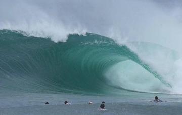
Beast From The East
For the past couple of weeks, it’s been generally quiet on the eastern front, with all the swell activity being focussed up into Western and South Australia. However, this is all set to change this weekend with an extended run of large surf from the east expected.
Though eyes are usually trained to the south, mid-winter east swells aren't uncommon. What is unexpected is the longevity of the coming swell.
At present, the northern half of the NSW coast is staring down the barrel of at least four days of large surf, likely starting windy and extra-large before organising itself and wagging a very long tail.
Backlit winter perfection (Brokensha)
The source of the swell will be an upper level trough currently moving across the country, which spawned off the strong cold outbreak that impacted Western Australia yesterday.
The high level instability will move across the continent before crossing the East Coast over the weekend, while an additional injection of polar air from the south will help provide the catalyst for the development of a broad low pressure system offshore from the Mid North Coast sometime on Saturday.
Another unexpected aspect of this storm will be the formation of multiple embedded lows around a broad centre, with multiple fetches of gale to severe-gale-force winds being projected on top of an established fetch of strong easterly winds - see image below.
This and the slow eastward movement away from the coast will create initially windy, raw XL surf, though as the low starts migrating away from the coast, westerly offshore winds are expected to kick in as the low continues to generate large surf.

Approaching frontal activity through the Bight and across the south-east of the country should bring favorable winds for nearly all next week with the low still generating swell into the following weekend as it broadens into a substantial trade-fetch north of New Zealand later next week.
There’s even the chance for a repeat, though much weaker, system into the following week, but that’s getting way too far ahead of ourselves.
Looking at the specifics and we’re due to see increasing rain and strengthening onshore winds as the low forms on Saturday, becoming larger through Sunday and likely reaching the XL size range later in the day, if not more so Monday.
The timing of the offshore change looks to be later Monday, with the surf up until then being mostly a write-off apart from novelty spots and locations north of the lows axis.
Tuesday onwards looks great as offshore winds kick in and the swell starts to become more manageable for a wider variety of locations.
At present, the leading global forecasting models ECMWF (European) and GFS (American) are fairly similar in make-up and evolution of this coming system but we’ll provide running updates in the commentary below while the regional Forecaster Notes will have more precise details as the weekend nears closer.
// CRAIG BROKENSHA


Comments
Any idea how it will affect Fiji Craig.
Shut-off the swell window unfortunately.
That is until the coming frontal activity moves into the Tasman possibly bringing some swell in a couple of weeks.
Any more clarity on where that axis might be? Forecast notes from yesterday mentioned one model indicating Coffs coast and another more north around the GC?
Looks to be just south of Coffs before migrating further south.
Hands up whos really excited for this event.......be honest.....
hands down, not me.
Yep agreed. I'm missing the 3-4ft south swells.
Nope.
On any normal year- this would be swell of the year type stuff- not sure at all what wave quality will be like with current sand set-up.
What is the king of all novelty waves? Newy harbour? Coffs?
Flint and Steel
I remember reading that was supposedly really good in July 2001 with that east swell that all the surf mags were frothing over…
Saw a photo of Mackerel on that swell, with Derek Hynd riding a big glider.
You lost me at Derek Hynd
What a swell...pumped for 3 days straight...spots that have never broken since were 6ft and reaming... and we beat the Lions in the rugby.
That was as big as it gets as good as it gets here.
Boat ramp was sick on the Good Friday macking swell
im a little excited ,not frothing but ,
time will tell
Sands just starting to come good in spots here. Like real good. This system has serious potential to Fck all of that well into the back end of spring now.
winds looking a bit more favourable now down south on monday? how much more variation could we see with this or is it fairly locked in now?
We could still see some wobbles but models are in good agreement now so you'd expect only minor changes.
How far down south?
illawarra way
Copy that- latest notes live
thanks, FR
Novelty spot only for me depending on wind directions
I think there’s a few novelty spots either side of the Hawkesbury…. Never surfed them personally….
Looks like something similar forming the following week a bit further north around the Gold Coast.
That low went down to Newcastle this morning, is now off Byron Bay this arvo.
https://www.weatherzone.com.au/satellite/nsw
such a waste of swell when the banks on the points are still shite , any other time it would so fun all over