
Autumn Review: Back In Black

Well the verdict is in: After three years of poor swells and winds thanks to a triple dip La Niña, the Southern Ocean is back in black.
The Victorian Surf Coast has seen a stellar run of swell and offshore winds, climaxing last Sunday with one of the best days of surfing in years. A large mix of groundswells provided pumping 10ft surf under perfect offshore winds, glassing off into the evening providing a huge silky canvas for those with the ability and heart to take it on.
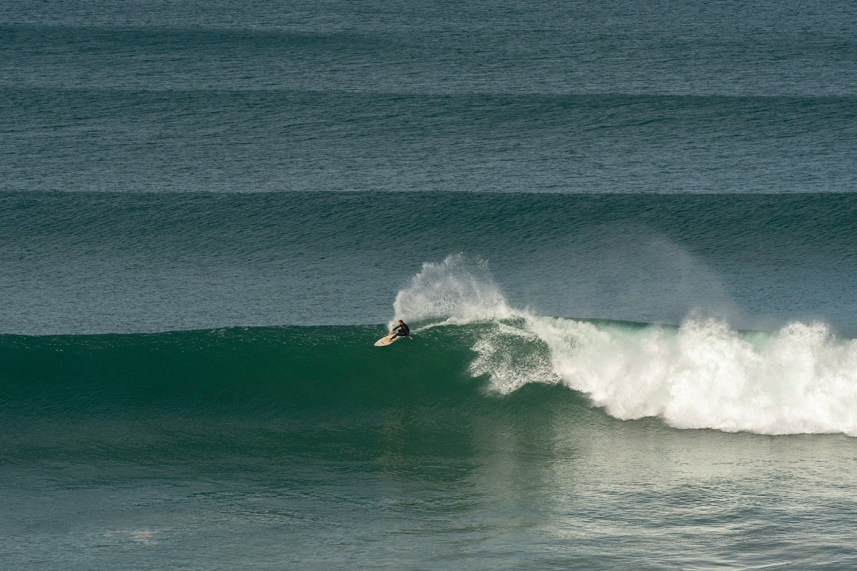
Casey Egan slicing Surf Coast perfection (Judy Scanlon)
The change in fortune is linked to the transition in sea surface temperatures throughout the equatorial Pacific Ocean. That being from a cool signal to a warming signal, La Niña to El Niño.
The curious amongst you may wonder how water temps in the Pacific Ocean can influence surf in the Southern Ocean. It's a good question.
During La Niña, the belt of sub-tropical high pressure shifts to the south, which is great for the East Coast as it increases the easterly swell energy. However, much as the sub-tropical high pressure belt shifts south, so too does the westerly storm track that runs below Australia, and this suppresses storms in the Southern Ocean.
Now that we're transitioning into a warming equatorial Pacific Ocean and El Niño phase, we've seen a return to normal Southern Ocean frontal activity which has been focussed to the south-southwest of Tasmania, Victoria's prime swell window.
This is clearly evident looking at the Mean Sea Level Pressure (MSLP) anomaly charts for the autumn just gone. The term anomaly means the difference from the long-term climate mean, and what immediately catches the eye is the big low pressure anomaly south of Tasmania. This indicates lower than normal pressure in that region through March, April, and May, meaning there was an increase in swell-creating frontal systems.

Mean Sea Level Pressure (MSLP) anomaly for March/April/May 2023

This is in stark contrast to last year (see image at left), where a large swathe of higher than normal pressure dominated the Southern Ocean as lower pressure enveloped northern locations.
It wasn't only Victoria's Surf Coast that benefitted from the setup seen above. South Australia, Tasmania, and regional Victoria all saw periods of favourable winds and swell aplenty.
Looking at the East Coast and while the regime has recently shifted to episodic southerly pulses spreading up through the Tasman Sea, there was still plenty of quality easterly swell through April and May thanks to the lingering effects of the weakening La Niña.
This can be seen as the weaker (compared to last year) but still persistent low pressure anomaly through the Tasman and Coral Seas.
After a slow March, the following months of April and May seemed to provide non-stop swell energy out of the east, becoming large at times and with favourable winds. It hardly dropped below 2ft and there were plenty of pumping sessions to chase across the East Coast's varying coastline from the Sunshine Coast to Eden.
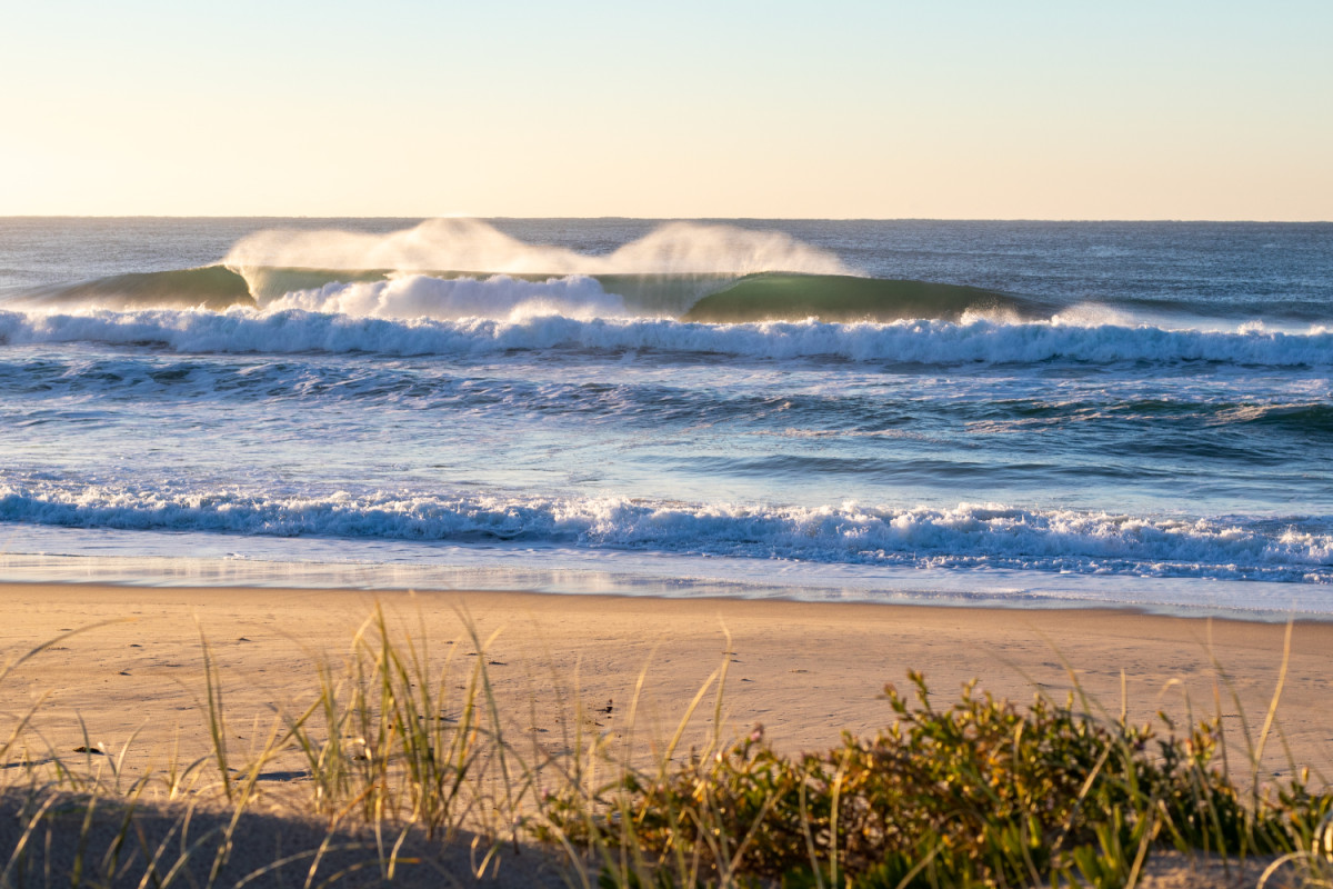
East Coast magic (Craig Brokensha)
The Tasmanian East Coast was also fairly consistent but on the smaller end of the scale as the easterly swells lost a bit of their punch once they pushed south of Bass Strait.
Over to the west, and the autumn was dominated by favourable winds and moderate to large groundswell events.
With the more distant sources, Perth and Mandurah weren't overly consistent, but the amount of clean, solid days in the South West were numerous. This is clear when looking at the mean (average) wind speed and direction for the past three months, with a south-east direction blowing across most of the West Coast.

Mean wind speed and direction for March/April/May 2023
Under the country the Roaring Forties roared, while the Coral Sea continued to provide persistent easterly winds.
The reason for the slow season in Indonesia can be seen in the first MSLP chart, represented by the large (blocking) high pressure anomaly sitting across their prime swell window, south-west of Western Australia.
With the El Niño signal continuing to strengthen throughout the Pacific Ocean we can expect the southerly regime to continue across the East Coast with plenty of activity for the southern states. How Indonesia and Western Australia will fare is unknown, though it looks like we'll see the first proper swell of the season hitting tropical waters during next week.
More on this over the coming weeks.


Comments
Classic sweet spot Autumn.
Cheers Craig.
been a long long time but thanks Huey
"The reason for the slow season in Indonesia can be seen in the first MSLP chart, represented by the large (blocking) high".
Thanks Craig, explains a lot as I peer out at another day of 1' dribble while it has been pumping at home. Clearly picked the wrong time for an Indo trip.
Onya Case - Fark that bloke knows how to shred and so casually. You can tell a good surfer from a bloody great surfer when it gets oversized and they are murdering it. Displacing water over been displaced
What a week it's been!
waves were huge on the mp - i drove from spot to spot…..(with zero intention of going anywhere near the water)
What about Western Port? Must have been cooking on a few of the reefs
W.P . Has been pumping!!. Yesterday at dawn was very good. Five days earlier on the incoming tide it was also quality surf all round. Finally we have proper late autumn/ early winter surf at W.P. just like we used to have 3-4 years ago.
Been an incredible run for the Surf Coast, must be a lot of surfed out punters this week. Last Tuesday surfed a well known reef with about 40 plus in the water, today was probably better but only 5 to 10 out. Plenty of unridden set waves, no one hassling, bit like the old days.
Funny to read about the slow Indo season. The insta pages of a few Ments camps I follow, it seems like it’s been pumping for 3 months…selective marketing perhaps?
For me, it was always in the back of the mind when surfing this three year period of non-stop quality surf, that it would come to an end.
It hasn't made it any easier when seeing the local turn from beautiful banks and peaks to long, straight handers with the shift in swell regimes.
It's great to see the Southern Ocean come back to life though! It's well overdue.
Same for me, seeing these south swells glancing the coast has reminded me what it was like. Glad I had the job flexibility to score lots of waves over the last 3 years. So many amazing sessions.
I'd just about convinced myself that my local was actually a good spot; last couple of months has been a reality check!
Had to get reacquainted with the hasslers at the actually-good spot round the corner...
#1stworldproblems
Given the location of that MSLP low, is it safe to presume that the 2023 autumn Vicco swells have been more southerly in direction than what is considered normal? And therefore sneaking past Cape Otway with more size?
Yeah, more south than west, for sure.
100% bells has been barrelling more often haha
Does that mean Perth will get some? I see some swell in the next couple of weeks - a sign of this change?
Seems like it's been a couple of lean years.
I thought the last couple of years with mid-latitude storms, erosion and generally favourable winds in between big blows was fairly consistent? This year looks less so.
Seems like the 3-4ft offshore days (which is 10/10 for Perth) were not as frequent, but maybe I'm just working too much, and missing those more than I used to.
Your right it’s been shithouse for a couple of years at least at my beach half way between Mandurah and Rockingham beaches still very wide and straight waves the norm the storm over the long weekend may have changed this ,let’s hope so .
Thank god! It was starting to feel like La Nina was the new normal
Hope everyone has their water tanks full, it is hard to imagine at the moment after three wet years but the BOM forecast for a big El Niño plus positive IOD will make for a very dry year ahead.
https://www.abc.net.au/news/2023-06-01/warm-dry-winter-tipped-for-virtu…
I'm hearing ya. Tanks are low already, and the country around me is drying out quickly. Already started some clearing and fire management because it's looking sketchy ahead. Looked promising for rain and swell next week a few days back, but that forecast has fallen apart. What's a normal year look like?
Good question Tiges.
This has been the most normal year for a while IMO.
Average Summer with plenty of SE trades.
Normal Autumn and now moving into a typical dry Winter/Spring pattern.
Amazing how quickly the country dries out though.
Yeah it has been, but it seems only like a window during the transition. We haven't had decent rain in 3 months. That last rain event about a month ago that dropped around 100mm on SE Qld/nth NSW didn't really penetrate any further south than Coffs. March was really hot, April felt normal and May was early winterish. Maybe just a bit more accentuated in my neck of the woods, but feels el Nino entrenched already.
Yeah, definitely feels like El Niño here now too.
Which ain't a bad thing.
El Niño winters tend to be very pleasant around here with lots of clean, small S swells and offshore winds.
Then it turns very nasty during Spring.
@Craig
I recently watched a youtube video that was saying the Tonga Volcano that blew it's top recently contributed greatly to the SAM moving south during the last couple of years. Looks pretty interesting and it would be good to get your take on it.
The section on the SAM is around the 5 min
Yep, been covering this a bit in weather articles last year.
It's complicated but the eruption injected huge amounts of water vapour which is a greenhouse gas into the stratosphere, about 10% of what already exists naturally and this will bring a warmer trend over the coming years.
There was also the injection of sulphates and other aerosols which could have helped provide extra nuclei for rain to form on, enhancing the precipitation rates and totals seem during our wet signal.
As well as that, the sulphates and other aerosols blocked solar radiation, leading to a significant cooling of the stratosphere. 12° below normal through October and this looked to have made the polar vortex very large in area, allowing cold air to escape the poles, manifesting in strong cold outbreaks into late spring and summer in Australia.
So there are so many downwind effects from this eruption, the largest in modern observing and sensing times. As such scientists are still discovering how it's affected local and global climate and trying to predict the lingering effects for the years ahead.
Incredibly interesting.
The change in swell regime from consistent E to consistent S has been terrible at my local beach. In general, it's not a great beachie. Except for favourable swell direction, one turn then a closeout floater is the standard fare. I'm sure Brazilians would feel right at home.
However, since that series of large S swells we've got a North Coast-style storm bar stretching almost the length of the beach. It's now more of a closeout than ever. Even Italo couldn't find space to turn.
Hasn't been like this in a few years. Before La Nina at least.
One more reason to miss the little girl.
Opposite around here, small little S swells are favourable and if you keep your eyes open, all sorts of fun little sand bars form up along cliff lines, usually unattended.
I keep my eyes on them rock fishing.
It's incredible how quickly they form up.
Not usually very stable but in small El Niño winters they can be persistent.
Likewise, finally some banks returning after years of E swell straight handers. Encouragingly, hasn't taken long either. I'll never bad mouth S flat spells again, sand loves it.
While we're reviewing autumn, anyone know why there were so many bloody jellyfish around (northern beaches)?
Initially they looked to arrive with that super warm surge of the East Australian Current, but then it looks like they possibly sheltered in the Hawkesbury/Sydney Harbour and then have been slowly dying out while coming in and out with the tides there.
But the initial pulse looked to be with the EAC. Would love to ask a Marine Biologist.
What sort of jellyfish?
Big, blubbers, these..
Yeah they're the ones.
Sting a little bit, but not too bad.
Yeah, some didn't sting much at all, but I hit a couple of them, and it was like a bad electric shock, and then welts like a blue bottle! Touching the underside.
Seems they were most potent when they first arrived.
Look a little like overgrown jelly blubbers, but with tentacles/stingers. Translucent but a kinda burnt orange colour. Range of sizes, from around a fist up to a dinner plate. Big swarms of the bastards.
I'll see if I can find a picture online
Interesting, yeah I think you're right on the timing when they first showed up.
Can't recall ever seeing so many for so long around here.
Haven't seen any in the water this week, but still plenty of dead ones on the high tide line.
They are Catostylus (sp) which form large aggregations, often in harbours and estuaries.
Could easily have been seeded by EAC and then formed colonies in Hawkesbury and Sydney Harbour.
They are know to extend all the way down the Eastern seaboard.
Usually creamy in colour in temperate NSW, more blue coloured in sub-tropics due to presence of different sp of symbiotic algal cells.
Normally a burning, itchy sting, but nowhere near as severe as bluebottle.
Yeah sounds like them.
I feel Bali has been well below par the last couple of seasons and this year
you can add very late trade winds developing and lots of onshore drible.
Just came back from east Indo, pretty much a full month of surf in the 1-3ft range with a handful of unsurfable days, wasn't looking to flash when I left either. Crew bailing out everywhere. Narrow swell window where I was tho. Still a month of nothing in indo this time of year, pretty unusual.
And in the meantime Perth looks like one of the worst beach breaks you'd ever lay your eyes on
Borderline un-rideable with backwash closeouts the norm
On average 1500m to 2000m closeouts
Take off, go straight and repeat
Sand in all the wrong places
Surf reports still talk it up it though
Non stop swell on the Mornington peninsula of late and generally favourable winds. Keep it coming!
Thanks again Craig. Noticeable trains of big lows under Oz at the moment which then send those long period south (west) swells refracting into east coast.
Banks at the local are all over the place but I’d have that every time compared to stable blobs of sharply rising banks that do no one any favours.
Those jellies, oh man I have frightful memories of them from childhood swimming at Ramsgate or Brighton Baths. They infest Botany Bay. Normally Maroubra isn’t troubled by them but they came by here as well for a spell. Usually associated with sea lice as well, you might think you got away with it then you have itchy bites that last for a week, usually under your speedos. Hate ‘em.
Interesting in that first chart of yours Craig that shows the low pressure anomaly directly below Tassie, but high pressure anomaly SW of WA and SE of NZ. So it's a very narrow "band" of low pressure anomaly. Why just in that narrow window?
That's a great question Don, and I'm unsure of the answer. IE why the low pressure anomaly has surfaced south of Tasmania. Might need a deeper think.
Here's the global overview.. You can see the anomaly south of South America is stronger, as is that in the North Atlantic.
Thanks Craig. perhaps the southern most land masses are having an affect on these lows? Because once away from land it appears to be where the high pressure anomalies are.