
NE windswells favour south of Yamba, with small S spikes next week

South-east Queensland and Northern NSW Forecast by Steve Shearer (issued Fri Nov 7th)
Features of the Forecast (tl;dr)
- Another small NE windswell event favouring the MNC-Yamba stretch, peaking Sat with winds shifting NW as low approaches
- S’ly change Sun up to the border, with small leftover NE windswells and a late kick in S swell across the MNC
- Small but fun S/SE swells Mon with moderating S/SE winds
- Small leftovers Tues with light winds
- Small flush of S swell Wed south of the border with light winds tending NE
- N’lies increasing later next week with NE windswell
- Potentially a stronger long period S groundswell next weekend but N’lies a problem
Recap
A small blend of S and E swells in the 2ft range (1-2ft in SEQLD) were the main energy in the water yesterday with some clean conditions on offer early under light/variable land breezes before SE-E winds kicked up. Smaller today, mostly in the 1-2ft range or less with clean morning conditions before NE winds kicked in.

Easy run out the Bar this morning with just tiny waves on offer
This weekend (Nov 8-9)
No great change to the weekend f/cast. Weak high pressure in the Tasman with an increasing N-N/NE infeed into an approaching cut-off low and trough system. A proximate fetch of N’lies favours the MNC-Coffs stretch for size, extending up to Yamba with NE windswell to 2-3ft developing. Expect smaller surf the further north you go with SEQLD remaining in the 1-2ft range or less with N’lies. Not much happening north of Yamba apart from a small grovel on the back beaches.
Sunday looks a bit more interesting. A S’ly change associated with the trough and cut-off low moving away will be tracking up the coast with early W-W/NW winds across the MNC to North Coast- still N’ly north of the border. N’lies remain all day north of the border but the change looks to reach Coffs early morning, Yamba-Ballina mid morning and the rest of the Far North Coast by the a’noon, with the change looking to stall around the border-keep tabs on local winds around that region. Surf-wise, some small NE windswells for the North Coast to 1-2ft. S swells should start to build later a’noon across the MNC to Coffs, possibly just filling in on dark across the rest of the North Coast to 2-3ft.
 Next week (Nov 10 onwards)
A decaying ridge Mon quickly breaks down as high pressure moves NE into the Tasman. That should see light SW-S breezes in the morning through NENSW into the Gold Coast, more S-SE further into SEQLD- with winds tending SE-E and easing through the day. The morning looks good with mid period S-S/SE swells in the 3-4ft range across NENSW, smaller 2 occ. 3ft at SEQLD S swell magnets. Nothing amazing but worth pouncing on this time of year.
Small leftovers to 2ft at S facing beaches Tues with winds swinging N’ly as a front approaches and moves into the Tasman. There should be a small grovel on hand early before the wind gets up.
Another weak ridge then sets up Wed as a weak high cell moves NE into the Tasman, with light land breezes tending light N-NE in the a’noon. Some workable S swell from the front in the 3ft range offers a fun wave at S facing beaches in NENSW- not much for SEQLD. It’s just a quick up and down, gone by Thurs so get in Wed for a shred.
N’lies then kick back in Thurs into the weekend.
Another frontal system linked to a deep low passing under Tasmania approaches later next week (see below). Still too early to have much confidence in specifics but at this early stage indications are of a swell of much greater quality as the parent low and gales become slow moving and the system intensifies.
 We’ll look at size and timing on Mon but we should see an initial pulse build in Fri or Sat then a stronger, longer period swell later Sat or into Sun, potentially up in the 4-5ft range at S facing beaches in NENSW and some outliers on the reefs. N’ly winds look to be in the house during this time.
Check back Mon for the latest on this swell and in the meantime, gave a great weekend!
Latest news
US Surfing Gets Certified, Again

'Southern Edge' Tour Dates
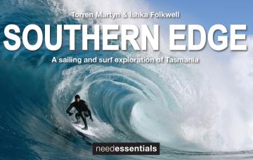
A sailing and surf exploration of Tasmania.
2026 Margaret River Pro: Day 2

"Surfing IQ was at a premium: navigating warped, wobbly, yet sizable chunks of water."
2026 Margaret River Pro: Day 1
A day when too much pro surfing was...too much.
Forecast: 2026 Margaret River Pro
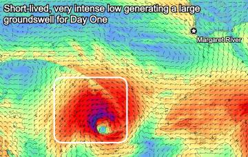
We're set for a cracking opening day of the waiting period before onshore winds set in.
Trouble Shooter // The Five Fin Surfboard
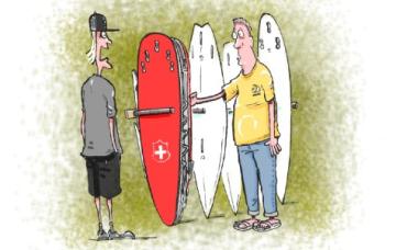
Muzz explains the "each way bet" shapers have when they throw five fin boxes into a board.
A Return To Caloundra Bar?

Hoping to stop erosion, authorities are dredging Bribie Island, but will the bar ever return?
Comments
Gah. Awful
20 to 30 kts of nor-easter Sat, produced about a foot of windswell into Sun.
Surfed a one foot gurgle peak with my wife on a mal in very chilly water.
No-one out and we had fun.
Went back on the low tide and it was breaking way out the back on the very, very low tide.
This time 0.5-1ft and freezing cold water- had to be the coldest water of the year.
Byron buoy showing 23 degree water- this had to be 17 or 18 inshore.
Needless to say, no-one out. Managed 3 or 4 rides on a mal over knee deep water into ankle deep water and stacks and stacks of small stingrays.
O/night Saturday the Byron buoy dropped to 18.2 degrees.
The buoy sits 5km offshore (currently offshore from Ballina) so inshore water may be colder again, especially after roaring northerlies.
Yep, copy that Stu.
Can often be a big diff between 5nm out and inshore during these upwellings.
Interesting how many N'ly episodes this spring and this seems to be the first real upwelling.- despite the EAC really kicking into gear last week.
Surfed in boardies both sessions and my wife said I was blue when I came in from second sesh.
I stepped on a stingray when I was surfing in Peru. Probably some of the worst pain I've experienced. Is that the same with Australian stingrays?
yep. very bad pain.
I bought a water therm from Bunnings a week or so ago out of curiosity about how accurate offshore bouys are with their readings and boredom/0 surf.
Ballina back beach was about a degree or two under the bouys reading but i was right on the Shorey waste deep max, just before the gutter. the water where i was measuring was easily warmer then out the back on the bank we were surfing the day before.
I agree yesterday was absolutely freezing, was in boardies and took away from a fun surf as the sand is ok in spots.
On the Oz east coast, when the wind is persistently north then the inshore water will be noticeably cooler than the MHL waverider buoys due to Ekman transport (in southern hemi, surface water moves 90 degrees to left of the friction force applied to it). So inshore water moves east and cold water upwelling replaces it.
All other directions see mixing of EAC with inshore water, though I usually find inshore to be a degree or two lower than the buoys.
In short: Hard to check accuracy of MHL buoys by taking inshore temp readings.
Yep stu, the whole experiment was to see how accurate the buoy is, as I figured it would have to be off. When i measured it was also 23 on the manly hydraulics site. I did this probably after a run of 3-4 days of north wind so i figured that would be the best time to test as the nearshore water would surely would have been pushed offshore with the cold deep stuff pushing through to replace. Anyway spot on a couple degs lower as you’ve found
Yesterday afternoon looked as close to flat on the Tweed as I've seen in a long time. Was almost tempted to crack out the fins, mask and snorkle off the point but was wary of the upwelling temps. Thanks for confirming my suspicions re: inshore SST - glad I didn't!
Yeah all that wind and yesterday really struggled with size, today's swell not really showing yet either.
Def building, been watching for hours now as I got the day off, just waiting for a tad more water and energy, twice the size since dawn where im watching
Nice! Had the alarm set at 4:50am checked the buoy quickly and pressed snooze.